Maps are an incredibly useful tool. They allow us to both analyze and communicate our research, and help us easily decide between (and then change) the various qualities, behaviors, attributes, and phenomena we want to relate and link together in space. Maps represent back to us our realities, oftentimes in a neat little square, wrapped up as a jpeg file. I’m going to repeat part of that again: maps represent our realities. Digital tools like the mapping technology GIS (Geographic Information Systems)–as we all must take care to remember–are socially and historically embedded. Maps are never the space itself, but are limited representational technologies of that space.
When we fail to remember that all maps are partial maps, that all maps are situated maps, we are in danger of naturalizing maps as something objective that exists outside of our own knowledge frameworks. When a map is extracted from its cartographic context, the relationship between map and maker is severed, obscuring the origins, intentions, and uses that guided its cartographic process in the first place. Cartographic technologies simultaneously empower and burden us with opportunities to either normalize and legitimate impositions of power, or counter and unmask them. To critically engage with and ethically use GIS in my own scholarship, it is helpful to remind myself of cartographic history and the development of GIS so that I might side-step the pitfalls and problematics that beguiled and deluded the geographers before me.
Whether you’re learning to use GIS and cartographic methods on your own, in coursework, or perhaps through a workshop led by a fellow at the Digital Initiative, you likely won’t learn about the history of mapping beyond, perhaps, the Gall-Peters vs. Mercator projection debate and its moral that all maps are distortions and thus are misleading in one way or another. But cartographic controversy actually dates back to the beginnings of managerial map-making. To rectify the the limited scope in popular cartographic history, I present to you an extremely abridged and partial history of mapping, from manual cartography to ArcGIS, in a few parts. Part one is below. Part two will come in another blog post.
Part One: Some Bad Cartographic History
Modern cartography was developed as a weapon for imperialism—-maps were a tool for effective and efficient violent dispossession. Surveyors were sent alongside imperial soldiers, mapping the landscape that was in the process of being conquered and legitimizing the conquest as it unfolded. With cartography, Pope Alexander VI was able to draw a line between Spanish and Portuguese possessions in the *Inter caetera* in 1493. The geographic partition of India imposed by the British empire in 1947 and legitimated through maps upended the lives of millions of people.
An important precursor to GIS and spatial science is the development of central place theory, developed by German geographer Walter Christaller in 1933. Central place theory was an attempt to use mathematics to understand why towns are located where they are, and where towns should be built in the future. Christaller developed an optimal model for urban development, arguing that towns and cities should be built in hexagonal relation to one another, and the distance between the settlements is determined by what services each settlement has to offer other settlements.

If you’re getting an icky feeling about the imposition of geometric order on community development, you have good intuition. Christaller believed that areas that did not conform to his hexagonal model were irrational, and he worked as a planner for Himmler’s SS during WWII. For the Nazis, Christaller developed a plan for executing an ideal spatial order for redevelopment of eastern Europe, particularly Poland. Christaller’s model was also used to plan the locations of train lines and concentration camps.
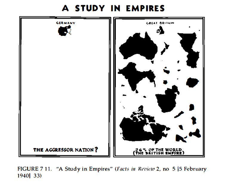
Nazi Germany requires more attention for its use of maps and spatial analysis in pursuit of genocide. During WWII, before the United States entered on the side of the Allies, the German Library of Information published a New York City weekly magazine called Facts in Review. In this magazine, Nazi cartographers published distorted historical maps to decrease American support for Great Britain and France in hopes that the US would stay out of the war.
One of the Nazi maps, for example, compares Germany to the British empire and casts Britain as the global aggressor.
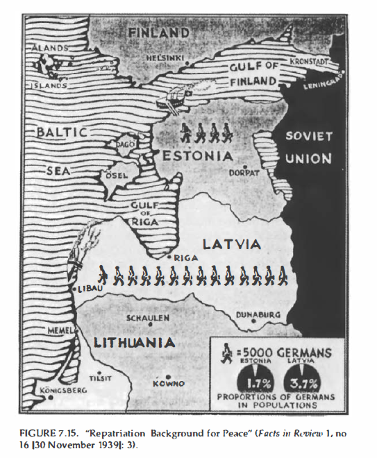
Another Nazi map presents Germany to the US as the peacemaker for the Baltic states. In the accompanying text to the map, Facts in Review states that “Germany is not afraid to correct mistakes of geography and history.”
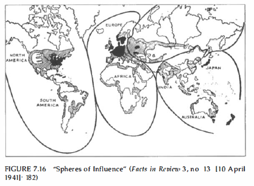
The infamous “Spheres of Influence” maps was also published in Facts in Review, encouraging the US to stay out of Europe.
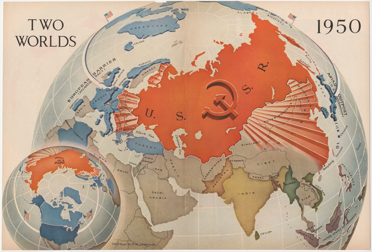
Not dissimilar to the Nazis, the US employed misleading and distorted maps for political means. North-polar projections were favored by the West during the Cold War to over-emphasize the threat of communism “looming” over the rest of the world. This anti-communist map was published in *Time Magazine*.
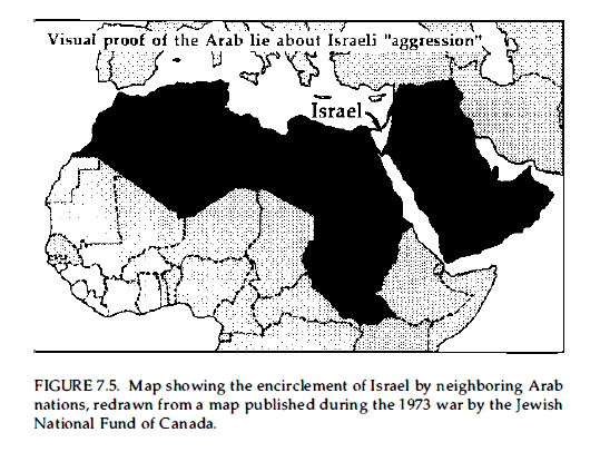
Even when a projection may be acurate in its portrayal of area, area without context elides a lot. This map of the middle east created during the 1973 Arab–Israeli War sets up a David-and-Goliath narrative, yet says nothing about the mismatch in military technology or Western support between Israel and the coalition of Arab states.
I remind you of this sordid history not to dissuade you from using GIS in your research, but to offer the context of the development of GIS. These maps are often cited as examples of mapping “mistakes,” but history shows us that they are not, in fact, mistakes. They were made with deliberate intention. The cartographic choices we make can have serious consequences, the technology we use comes with a lot of power, and it’s important that we take care in its use. Stay tuned for Part 2 where I’ll cover the development and use of GIS!

This entry is licensed under a Creative Commons Attribution-NonCommercial-ShareAlike 4.0 International license.